Climate change: Boston has the highest percentage of properties at risk of flooding in England


The data, published last month, also shows that 519 people in Boston are deemed at ‘high risk’ of flooding.
There are 43,414 properties in the borough at some degree of risk from flooding – with 725 deemed ‘high risk’, 3,093 facing a ‘medium risk’, 39,590 at ‘low risk’ and six at ‘very low risk’.
Advertisement
Hide AdAdvertisement
Hide AdThese figures account for 94.4% of all properties across the borough – a higher percentage than anywhere else in England.
By comparison, the larger district of East Lindsey is ranked fifth, with 6,600 homes at ‘high risk’. The district has a total of 79,246 properties at some risk of flooding, but this only equates to 54.9% of all properties. South Holland is just behind Boston, placed second for the area with the highest percentage of properties at risk of some flooding in England.
The ‘high risk’ EA grading equates to a risk of flooding greater than 1 in 30 (3.3%) in any one year.
The data also looks at how many people are at risk of flooding, by local authority.
Advertisement
Hide AdAdvertisement
Hide AdIn Boston borough, there are said to be 71,168 at some degree of risk from of flooding (95.2% of residents) of which 519 people are deemed at ‘high risk’.
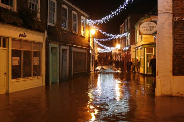
On December 5, 2013, a tidal surge caused the River Haven burst its banks in Boston, devastating numerous homes and businesses across the town. More than 50 streets across the town were hit, with around 800 homes affected.
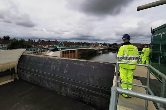
Since then, the £100 million Boston Barrier has been constructed – becoming fully operational in December 2020. This Barrier gate can be raised in just 20 minutes and is said to provide flood protection to more than 13,000 homes and businesses in the town. It was first put into use on November 7 last year following a high tide warning for the area.
However, these new EA figures take into account the additional protection offered by the new barrier.
Advertisement
Hide AdAdvertisement
Hide AdAn EA spokesperson said: “The National Flood Risk Assessment data shows the probability of flooding each year in an area taking account of flood risk management infrastructure, such as flood walls and embankments. Flood risk management infrastructure reduces but cannot completely eliminate the chance of flooding as they can be overtopped, sustain damage, or fail.
“The land around Boston is flat, low lying and almost entirely below sea level so there are still some areas vulnerable to flooding and we work very closely with partners to adapt and find solutions to reduce this risk in a way that works for the community.”
“The Boston Barrier Scheme’s primary barrier gate was declared officially operational in December 2020, providing better protection for 13,732 properties. As a result, many areas in the associated flood risk map have been updated from ‘high’ to ‘low risk’.
And more protection is on the way from the Boston Barrier project, with work ongoing over the next two years to better protect an additional 524 homes.
Advertisement
Hide AdAdvertisement
Hide Ad“Work downstream of the primary barrier is still on-going and will better protect a further 525 properties in the future,” the spokesman continued.
“The next stages include installing a replacement flood gate at the Port of Boston wet dock entrance, and work to connect the project to the completed Haven Banks Improvement Scheme which better protects properties downstream of the Barrier.
“This work will bring the total number of properties better protected by the Barrier Scheme to 14,256. The Boston Barrier Scheme as a whole is expected to be completed in 2023/24.”
The UK is already feeling the effects of climate change – with Coningsby recording record-breaking temperatures of 40.3C this summer. Experts say that extreme weather like heat waves and floods will become more common with climate change.
.