
Wetland nature reserve plan for Horncastle flood-zone takes big step forward
The creation of a new, multi-functional wetland near Horncastle has taken a giant step forward.
The ingenious scheme, to turn an area that is prone to flooding into a nature reserve for wildlife, was first revealed by the Horncastle News in October.
It is earmarked for land known as Harrison’s Holme, south of the A158 between the River Bain and the River Waring, and is the brainchild of Lincolnshire Wildlife Trust and the East Mercia Rivers Trust.
The land is often waterlogged in winter, making it unsuitable for growing crops for grazing. But the scheme aims to reconnect the rivers to 1.4 hectares of floodplain, and improve the condition of chalk streams in the area.
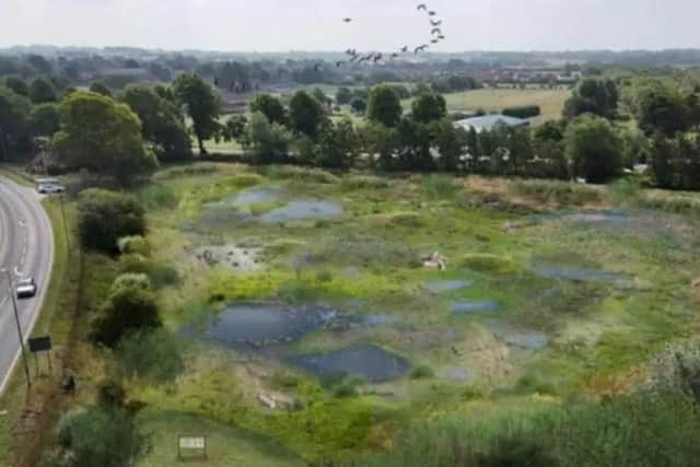

Under the proposals, it will be landscaped to hold more water, making it easier for the River Bain to flow, and micro-habitats will be created for a range of species to thrive in, such as amphibians, reptiles and invertebrates.
The wetland will feature ponds, scrapes, shallow swales, earthen bunds and native planting to boost biodiversity.
And although it won’t be accessible to the public, an elevated viewpoint, with seating and information boards, will allow visitors to see it without disturbing sensitive species.
Now a key milestone has been reached because all the surveys, tests and design assessments have been carried out, and the project is ready to go forward to the planning permission stage.
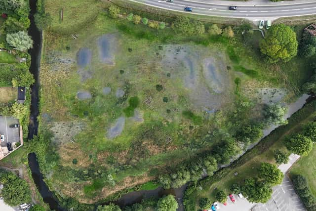
Much of the preparation work has been carried out by specialists at CBEC, an eco-engineering company for the water resources industry. It is part of the RSK Group, a global leader in environmental and engineering solutions.
Megan Annetts, of CBEC, said: “Ahead of any construction work on the project, detailed land surveys have been conducted to build an understanding of how the rivers currently behave.
"This helps to explore different design options and develop a comprehensive plan for how the new wetland should be built.
"The final design proposed by the CBEC team focuses on creating a high-quality, nature-rich space that also supports community access, education and long-term environmental resilience.
“Through restoring natural water flows, reconnecting the rivers to their floodplain and creating a wetland, the project will provide a better habitat for important species such as brown trout and water voles, while improving water storage to reduce flood risk and to benefit the area’s overall ecological health.”
To understand how different design ideas would impact this delicate natural landscape, options were tested with hydraulic and geomorphological models.
Megan said: “A vital element of the project is to create a wetland that increases habitat variability and stores water when it is needed, without creating unintended flood risks.
"The models are an invaluable tool in understanding how water will behave under present and future conditions and climate scenarios, helping to determine which design offers the greatest ecological benefit with the least risk."
A topographic survey was also undertaken, as well as desk-based land-contamination assessments, undertaken by sister company RSK Geosciences, to establish the potential contamination risk on-site.
Further desk-based heritage-impact statements, delivered by Headland Archaeology, another RSK Group company, have outlined the historical landscape of the site.
Megan went on: “These statements have explained the potential for Roman settlements and artefacts to be uncovered on the site.
"The report will be important when the project reaches the construction phase because it will guide the excavation depth limit to ensure there is no disturbance to any historical assets.”
Sam Valman, project manager at East Mercia Rivers Trust, said: “The technical design work and visualisations brought to the project by CBEC have helped meet the twin goals of providing the detailed information required to obtain permissions to carry out the work while providing materials to share the project with the wider community.”
Megan concluded: “This project represents a significant step forward in restoring the natural function of the Bain-Waring floodplain.
"Our team has now been able to design an urban wetland that can reliably accommodate out-of-bank flows from the River Bain and route them through a series of strategically placed floodplain scrapes.
"The restoration of this section of the river-floodplain system, combined with the creation of a multi-depth wetland habitat, will increase the availability and diversity of wetland niches for wading birds and other species.
"The project demonstrates how nature-based, process-led design can deliver measurable ecological gain while improving climate resilience within a highly modified chalk-stream landscape.”